By Molly Murphy
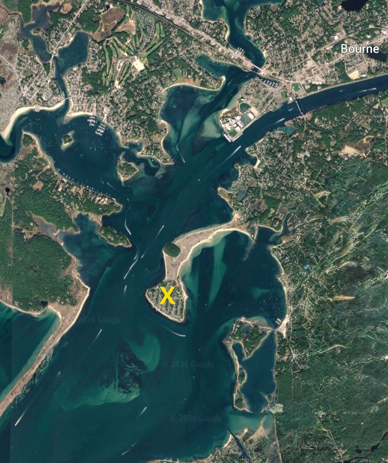
Most people passing through the Cape Cod Canal never notice it at all; a narrow peninsula wrapped in water on three sides, tucked between Massachusetts Maritime Academy and Tobey Island. With a lack of public parking and little reason for visitors to stop by beyond taking a look at the gorgeous waterfront homes, it remains virtually invisible. Yet this quiet corner of the Upper Cape has a rich history.
Going back a few centuries, the isthmus was actually once an Island. Originally home to the Manomets of the Wampanoag tribe, these natives spent their days traveling between Mashnee Island, Hog Island, and Tobey Island. It didn’t take long for the Pilgrims to build Aptucxet Trading Post in 1627, so they could utilize trade resources between these Natives.
At the time, Mashnee Island was primarily used for fishing, however with the town being overrun by wolves by the end of the 17th century, many sheep were transported there for grazing. The Natives slowly moved, and the caretakers of these animals moved into little shacks. The island began to industrialize, and Buzzards Bay became a primary location for salt harvesting. However, with the vulnerable landscape, most of the industry would wash away with every big storm.
During the 19th and 20th centuries Cape Cod began to be known as an ideal summer getaway destination. Bourne began to house many industry workers from factories outside of Boston, but the most famous Gray Gables resident was President Grover Cleveland, one of the first presidents to own a “Summer Whitehouse.” Despite Gray Gables’ high-profile summer residents, neighboring Mashnee Island would remain relatively untouched from summer residents for another fifty years.
By 1939, the island would be joined to the mainland of Gray Gables with the building of the Causeway. A product of the re-dredging of the Canal, as well as the aftermath of building the new bridges, the “Mashnee Dike” would serve as a safer approach to western end of the canal. The re-routing of the canal with construction of the dike helped to regulate tides and currents, allowing safer flow of water from Buzzards Bay into the Canal. This new Causeway utilized the soil and sand from the dredging to make the project much cheaper.
During World War II Mashnee Island, now a peninsula, served as a prime location for ensuring boats and their passengers could easily pass through the canal, unmolested by German U-Boats. Spotters were stationed on the island utilizing it as a Coast Guard lookout spot until 1947.
With the conclusion of the second world war, the island would see a drastic transformation. Building projects began as residential homes, beach clubs, and various entertainment spots appeared during the postwar era. The economic boom that occurred in the mid century resulted in more and more families buying second homes for the summer months. The quiet village of Gray Gables began to prosper as a hidden summer retreat, drawing in those who knew where to look.
Mashnee Island has been many things over the past few centuries, a prime fishing location, a trading hub, pasture land, and even a home for weaponry drills during WWII. It can be easy to overlook what makes this place so special, especially in a region typically defined by large summer crowds. Its anonymity is a large part of its charm, Mashnee Island does not have to try to impress people, but its quiet simplicity and rich history impress all who are lucky enough to discover it.